
Apportionment of Lerwick
Lerwick is one of two sites in the Shetland Islands operated
in the 1970s and 1980s by Britain's Atomic Energy Research Establishment (AERE)
in Harwell (the other being Collafirth). The group within Harwell produced a
series "green reports,' so named for the color of their covers, that
contained valuable data on aerosol and deposition at a dozen or so sites in the United Kingdom.
We have used these data to great profit over the years, and the current tracer
system is no exception. Collectively, the green reports showed that the aerosol
of the UK tends to have a distinct composition probably controlled largely by
the elemental properties of the coal and peat burned throughout the UK. The
AERE's studies of aerosol began with nearby Wraymires and extended northward
through Scotland and to the Shetland Islands, a remote and understudied place
whose latitude is 60°N, the same as Oslo, Stockholm, Helsinki, and Leningrad
(now St. Petersburg). The aerosol at Lerwick would thus be expected to be
influenced by sources southward in the UK, southeastward in Europe, westward in
Scandinavia, and perhaps occasionally far northward in the Arctic.
We have done a careful and thorough job on apportioning
Lerwick's aerosol. We followed each of the three strands that arose in steps 0
and 2: the Shetland Islands themselves, the UK and Europe, and the Arctic. In
the end, the most meaningful of these was UK/Europe.
The threads of the analysis are shown in the table below,
with links provided for quick viewing. Figures for the first two of the threads,
each short, are given below. The Arctic thread, somewhat longer and deserving of
more comment, is shown separately.
| Lerwick, Shetland Islands, 15 elements | |||
| Shetland Islands Thread | UK/Europe Thread | Arctic Thread | |
| Step 0 | Nothing chosen | ||
| Step 2 | Sea and crust (FEC) chosen | ||
| Step 3 | Collafirth added, fit 0.22 | Chilton added, fit 0.77 | Bear Island added, fit 0.75 |
| Step 4 | Styrrup added, fit 0.54 | Ny-Ålesund added, fit 0.67 | |
| Step 5 | Leiston added, BI/NyÅ disappear, fit 0.27 | ||
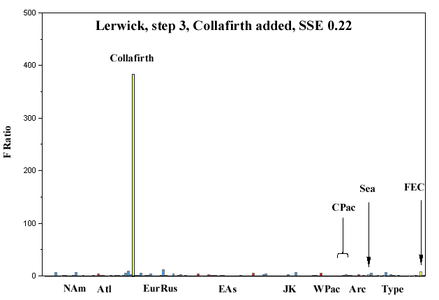
Step 0 of the apportionment, before any sources are selected, is shown below. F-ratios are especially high in a geographically coherent group of European sources around the United Kingdom, with nearby Collafirth (also of the Shetland Islands) being five times higher than anyplace else. Having a source in the Shetland call another sources in the Shetland Islands (which after all is a very small place) may seem to be a trivial result, but it is not really. Rather, it represents a control, or reproducibility exercise where duplicate but independent samples were taken nearby, analyzed independently for elements, and here interpreted independently. That the nearby sites prove so similar (and different from the other UK sites sampled and analyzed by the AERE Harwell group) shows that both they and we did things right.
Step 2 is after the sea and the crust have been entered into the least-squares fit. Two groups of sources remain: UK/Europe (with high Collafirth) and the Arctic. That opens three threads to be checked: Shetland Islands/UK, UK/Europe, and the Arctic.

The Shetland Islands solution
We begin with the Collafirth/UK thread. Step 3, after
Colllafirth has been chosen, shows that everything else disappears. The one site
in the Shetland Islands is explaining the other site there to the extremely good
fit of 0.22.
As an aside, Collafirth explains Lerwick very well (fit of
0.38) even before sea and crust are entered. The figure for this is not shown
here.
The UK/Europe solution
Steps 3 of the UK/Europe thread begins with Chilton, in the
UK, which has the highest F-ratio from this area. It provides a moderate
fit of 0.77. The F-ratio for Collafirth remains high.

Step 4 chooses Styrrup, also in the UK, and improves the fit to the very good 0.54. The F-ratio for Collafirth, like the gorilla in the closet, is several times higher than Chilton or Styrrup. This thread is terminated here because no significant F-ratios remain in Europe/UK.

The conclusion from these two threads is that is that there is a single aerosol for the Shetland Islands in general and that it most resembles aerosol in the UK to its south. Given the dominance of winds from the south and southwest in this region, and the documented transport of acidity from the UK to nearby southern Norway, this result should come as no surprise.