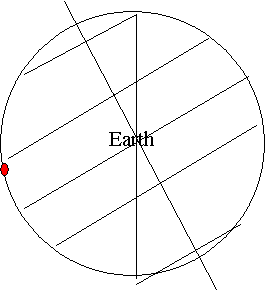
Axis Equator Tropic of Cancer Tropic of Capricorn Antarctic Circle Arctic Circle Circle of illumination Location of the overhead noon sun.

|
|||
 |
|||
Problem set for OCG123 Lab 2-Atmospheric Circulation and Coriolis Effect
0º – 30º 50 % 30º – 60º 36 % 60º – 90º 14 %
Because of the
curvature of the Earth, the same amount of solar radiation is spread over a
much lager area at the poles than at the equator. Consequently, each square
meter of surface receives proportionately less energy at the higher latitudes,
and the incoming solar flux thus decreases from the equator toward the poles.
Axis Equator Tropic of Cancer Tropic of Capricorn Antarctic Circle Arctic Circle Circle of illumination Location of the overhead noon sun.

|
|||
 |
|||
1) Temperature decrease with altitude in the troposphere.
Refer to the handout.
2) Temperature increase with altitude in the stratosphere.
Refer to the handout.
Solar radiation is the earth’s energy source. The more radiation the earth gets, the higher the temperature is. From question 1, we can see that the earth get more solar radiation for the same area at the equator than at the poles. So temperature is the highest at the equator and gets lower as we go to the poles.
Albedo is the energy reflected back to the space. The higher the albedo is, the smaller percentage of energy is absorbed by the earth. So as the poles are covered by ice which has a high albedo, they are even colder.
Heat capacity is the heat needed in order to raise 1 degree of the temperature of a material. The higher the heat capacity is, the less the temperature varies. As water has a really high heat capacity, the temperature of the ocean varied much less than the land which has a low heat capacity does. And it is cooler in the summer and warmer in the winter relative to the land.
(1 = slowest 5 = fastest)
2 57ºN 3 25ºS 4 10ºN 1 67ºN 5 1ºS
(1 = slowest 5 = fastest)
4 57ºN 3 25ºS 2 10ºN 5 67ºN 1 1ºS
The Coriolis effect exists because the Earth is a rotating sphere. The eastward velocity is different at different latitudes. The different of this velocity “causes” the Coriolis effect.
If the earth were a rotating cylinder, there would be no Coriolis effect.
If the earth were a nonrotating sphere, there would be no Coriolis effect.
(a) fig 4-11
(b) fig 4-14 in the text book.
Convergence;
In order to have precipitation, we have to have
a lot of water vapor in the air and then let the air cool to form clouds and
then, precipitation.
At the equator, the air is hot, so, it contains a lot of water vapor.
And as it is hot, it rises and get cooled. We get a lot of precipitation around
the equator.
Around mid-latitude, the air is sinking, as the air sinks, it get
warmed and prevent the formation of clouds. We can’t get much precipitation
around mid-latitude. And we can find a lot of deserts around 30N and 30S.
At higher latitude 60N and 60S, we have sinking air but the air is
less warm than at the equator so it contains less water vapor in it. We get less
precipitation here than at the equator.