
Spatial patterns of marine aerosol over the IMPROVE network
I first began to consider marine aerosol in the IMPROVE
samples when I noticed high Ca/Si ratios in seaside locations such as Point
Reyes National Seashore and Redwood National Park, both in California. Then when
I switched Pacific reference sites from Mauna Loa to the lower Haleakala and saw
the same noise and higher Ca/Si there, I wondered again about possible effects
from marine aerosol. Later I saw the same thing at Denali and checked there as
well. I found abundant marine aerosol at all these places and more. At first I
was surprised by the result for Denali, but then I remembered the ubiquitous
marine aerosol in Arctic haze. Later I was surprised to see the marine aerosol
penetrating farther inland, but remembered that I had found it in the middle of
the Northwest Territories in winter while working on my thesis three decades
ago. Marine aerosol can clearly travel long distances during winter, and its
fine-particle component (as sampled by IMPROVE) farther still. So it should come
as no surprise to find marine aerosol at many sites in the IMPROVE network.
It can be tricky to detect marine aerosol reliably, however,
especially where other aerosols are abundant. You can't just use Na as indicator
element, because it is abundant in rocks and so appears with crustal aerosol and
coal flyash. You can't just use Cl, because it is quickly lost from marine
aerosol wherever acids are also present. You can't just use elements like Mg and
Ca because they have strong crustal sources, like Na. The best way is to use the
double-ratio plots I developed a few years ago. To search for marine aerosol in
Na and Mg, for example, you make a scatter plot of Mg/Si vs. Na/Si and look at the high-Na/Si
end on the right. If Na/Si is high enough and a 45° (1/1) asymptote is found on
the right-hand end with ratio of 0.12, abundant marine aerosol is present and
dominates Na and Mg for those samples. If no asymptote is seen, marine aerosol
is either absent or below the limit of graphical detection. A few examples of
these plots are shown below, for Redwood National Park, in Northern California,
a site that receives much marine aerosol.
The first plot below is for Cl. As in all these plots, the
dashed orange line shows the bulk seawater ratio for the two elements being
considered, here Cl and Na. The ratio is 1.78, and appears on these plots, as
all constant ratios do, as a 1/1 line (45° for equal scaling of the axes). This
plot shows that over nearly three orders of magnitude, this seawater ratio acts
as a cap, or maximum value, for the Cl/Na ratio in the fine aerosol. At the
upper end of the plot, most of the values are close to 1.78. As the ratios on
the individual axes decrease, however, which means as the concentration of
marine aerosol decreases relative to crustal aerosol, more of the points fall
below the line. (The Cl is being lost as the volatile HCl formed by reacting
with HCl or H2SO4.) At the low end of the plot, hardly any
ratios remain undisturbed. This plot is typical for marine areas.

The next plot is for Mg and Na, the pair that I usually find to be the best indicator of marine aerosol. It displays a long, broad, irregular marine tail on the upper right. The length testifies to the importance of Mg as a marine element in aerosol, the irregularity to analytical difficulties with Mg by PIXE. The beginnings of a flat crustal tail is seen at the lower left. That it is not well developed testifies to the same to effects mentioned in the previous sentence.

The analogous plot for Ca is shown below. Its shorter marine tail and longer crustal tail simply mean that it has a higher relative concentration in the crust than Mg has. Note how the placement of this crustal tail, with most values of Ca/Si between 0.2 and 0.5, agrees closely with the crustal Ca/Si from Hawaii, 0.25 to 0.45. Comparing the plots for Ca and Mg gives a sense of why Ca can, under the conditions of the IMPROVE network, be the better indicator of marine aerosol.

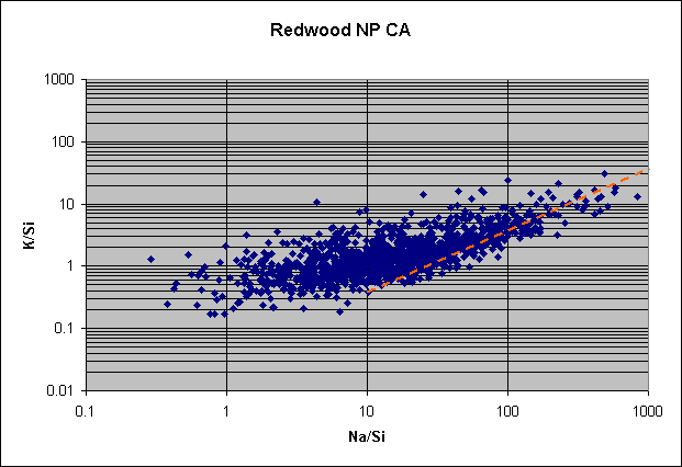
The "marine plot" for K, as I call them for short, is more irregular than for Ca, particularly on the high side. This may indicate additional sources for K, such as burning wood. The crustal tail is also more irregular than for Ca.
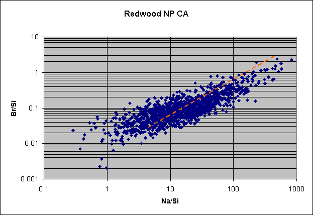
The marine plot for Br seems to show the beginnings of a horizontal tail around Na/Si = 10, but at lower ratios it begins to fall off again. There is a reasonably defined marine tail, although it is broad and falls well below the bulk Br/Na line. It has been known for many years that Br is lost from certain sizes of marine aerosol, even in clear marine atmospheres, but these depletions (about a factor of two) seem too large to be from that alone.
Even sulfur can display a sea-salt component when enough salt is present. This seems to be one of those cases, even though the marine tail has not yet fully sharpened. Note how the tail is approaching the bulk S/Na line near the upper end.

The next decision to be made is which pair of elements to use to detect
the marine aerosol. The knee-jerk reaction is to use Cl and Na, for then are the
more abundant in marine aerosol. Although they work well near the sea, the rapid
loss of Cl from the fine particles makes Cl not a good element for inland use.
The next-best pair should be Mg and Na, for Mg is less affected by crustal
sources than Ca and K are. But Mg does not work well in the IMPROVE data,
presumably because of bad detection limits because of its light atomic weight.
Br and I also don't work well because of difficulty in detecting their low
concentrations. (Iodine isn't even reported by IMPROVE. I have been spoiled by
many years of using neutron activation, which determines Br and I very sensitively.) Thus we
must turn to
Ca for indicating the presence of marine aerosol. Not only does it work well,
but it is useful here, for Ca/Si is the best way of distinguishing among crustal
aerosols, and it was what raised the question of marine aerosol in the first
place.
The slide show for marine aerosol via its effects on the
Ca/Si ratio uses scatter plots of Ca/Si vs. Na/Si like those shown above. They
turn out to be surprisingly sensitive, and have provided a map of effects of
marine aerosol over the U.S., the first such map that I am aware of. A few of
its features are described in the following paragraphs.
Broad distribution of effects. One might expect the marine aerosol to be strongest near
the Atlantic and Pacific coasts and to decrease rapidly inland, i.e., to produce
a U-shaped distribution over the U.S. To a certain extent that is seen, but with
some interesting twists. First, the marine aerosol seems to be stronger along
the West Coast and inland than for the East Coast. This may be a simple
consequence of the fact that the prevailing winds are westerly, not easterly.
Second, there is also a maximum of marine aerosol along the Gulf Coast. Third,
and perhaps most interesting, there is a maximum of marine aerosol along the
northern border, apparently in association with Arctic aerosol coming down from
the north during winter.
An example of strong marine aerosol along the West Coast was
given above, for Redwood National Park in Northern California. Here is the Ca
plot for a comparable Atlantic site, Brigantine National Wildlife Refuge, NJ.
Note how much less marine aerosol there is at this site. This effect seems to be
true up and down the East Coast.

Here is the Ca plot for Shining Rock Wilderness, NC, a site that is about 300 km west of the Atlantic Ocean. There is only a hint of marine Ca there.

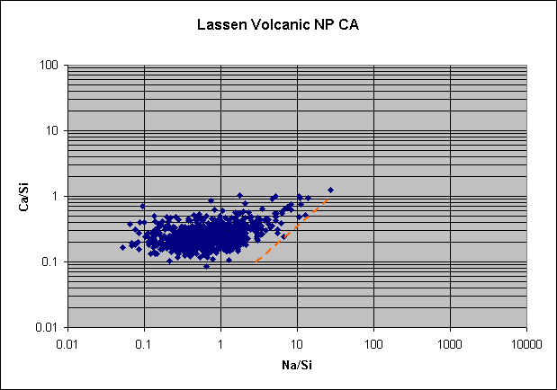
By contrast, marine aerosol can be seen penetrating eastward from the Pacific with relative ease. Along the Sierra Nevadas there is always a distinct marine tail, exemplified below by Lassan Volcanic NP in Northern California.
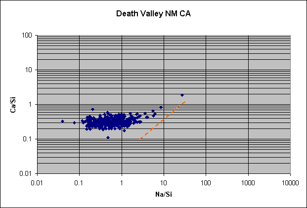
There is a very interesting series in Southern California, where marine aerosol can be seen penetrating 450 km eastward from Pinnacles National Monument through Sequoia National Park and into Death Valley National Monument:


As noted above, marine aerosol reaches farther into the West. Here are plots from Sawtooth NF, Idaho, and Yellowstone NP, Wyoming, relatively northern sites, that both show a short marine tail.


Here are two sites farther south, Brooklyn Lake, Wyoming, and White River National Forest, Colorado, that show the same thing.

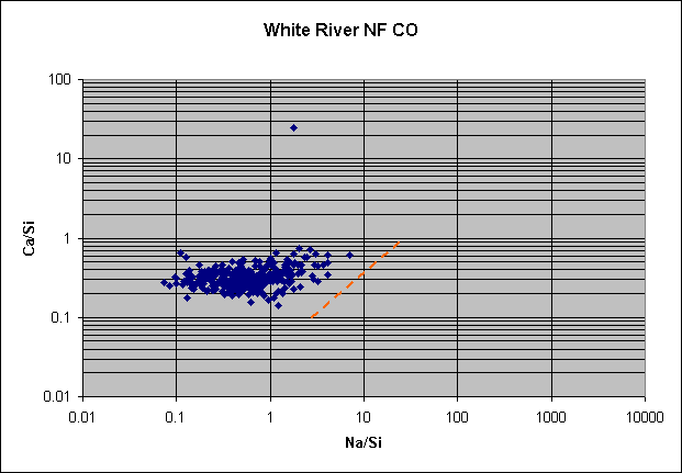
White River NF is nearly 2000 km from the Pacific Ocean.
Another interesting question is the extent of marine aerosol
at the three Hawaiian sites that serve as a reference for Pacific aerosol on its
way to North America. The site usually used for reference, Mauna Loa, is high
enough to have minimal marine influence, as seen in its plot for Ca:

Bur there is an influence, nonetheless, even though it is often claimed that upslope/downslope sampling prevents it. The site I tend to use for reference because it has concentrations that more closely match the ones reaching North America, Haleakala, has a much greater marine influence:
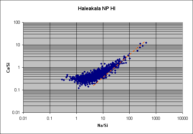
And Hawaii Volcanoes has a still-greater marine influence.

Denali, at the foot of Mt. McKinley in interior Alaska, has a surprising amount of marine influence:

Most of this influence is found during winter, probably in association with Arctic aerosol. When this aerosol is transported, also during winter, to the north-central U.S., it produces marine tails for Ca there, as illustrated below for Voyageurs National Park, Minnesota.

Thus marine aerosol reaches all four borders of the continental United States.
A second interesting topic coming out of these marine
plots for Ca is the various crustal Ca/Si ratios they reveal in the crustal
asymptotes at the far left. The sites in Hawaii show a single crustal Ca/Si
ratio, roughly 0.25 to 0.45. That is the ratio seen along the Sierra Nevadas,
particularly during winter and spring, and in clear interior sites in Idaho and
Colorado. A lower ratio, sometimes down to an average as low as 0.2, is seen in
much of the Pacific Northwest, however, particularly during summer. This is
presumably the local crust. Asymptotes throughout the Southwest are closer to
the higher value, particularly during winter and spring.
Things are different in the East, however. There the native
aerosol seems to have a high Ca/Si ratio, somewhere around 0.3 to 0.5, but the
overall Ca/Si ratio is abruptly lowered in summer (as seen in the slides of
Ca/Si ratio above) to values that can reach 0.1. The lowering agent is Saharan
aerosol with its extremely low Ca/Si ratio of roughly 0.1 The Saharan asymptote
is best seen at the Virgin Island site, as shown below.
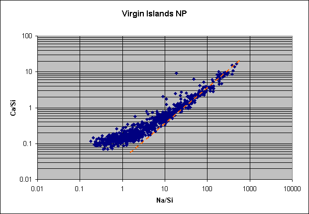
The Ca/Si asymptote, not fully reached, has a value no higher than 0.1. Set against native eastern ratios of closer to 0.4, it is not surprising that marine plots for Ca sometimes split at the crustal end, i.e., show two asymptotes. An example is shown by Cape Romain National Wildlife Refuge, NC, offered below.

The two asymptotes appear to be something like 0.15 and 0.3, from Saharan and
local sources, respectively.
An intriguing puzzle is posed by the Ca/Si asymptotes for the
north-central states. The values, which center around 0.3 to 0.5 or so, are
higher than those in much of the interior West (0.2 to 0.3 in summer and fall,
which represent local crustal aerosols) and are indistinguishable from those
over the Pacific. If they represent Arctic aerosol, they should match the Ca/Si
ratios at Denali in winter. But Denali's are Recall also that the seasonal
variations for Si at Denali were indistinguishable from those in Hawaii. The
last piece of relevant evidence here is the asymptotes for Denali, which appear
to center on 0.2, well below the values for the Pacific and for the
north-central states. What does this all add up to?
PowerPoint slide show for Ca/Si vs. Na/Si
Ahead to temporal patterns of marine aerosol
Back to Ca/Si