The IMPROVE data for Si
One cannot study these slide shows in a rush. I have
found it most profitable to wait until my mind is clear and my spirit is
relaxed. For me, this is usually after dark on a night when I do not have to
prepare for classes the next day. I sit down, open up the desired PowerPoint
show, make it full screen, and just explore. I cannot feel comfortable with any
particular show until I have done this several times over the course of a few
weeks. Only when I have a good idea of what to expect can I put the patterns
into the appropriate categories.
I have found the following sequence helpful for Si. I begin
with the West because I am most interested in how much Pacific Si reaches North
America. (As noted above, I still decline to call this material blanket
"Asian," for we do not know that for sure.) I start at the top, in the
Pacific Northwest, and work my way down from Washington through Oregon and into
California. Then I move eastward into Idaho, Nevada, Utah, Arizona, Wyoming,
Colorado, and New Mexico. The next paragraphs describes the patterns I see.
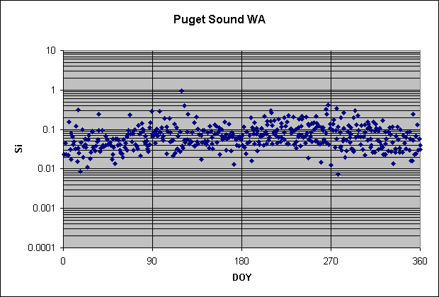
The two northernmost sites in Washington (North Cascades and
Puget Sound) show nearly flat patterns for Si. (That means that concentrations
are not so low in winter and not so high in summer.) The plot for Puget Sound is
shown below.
Moving southward, Snoqualamie, Rainier, and Columbia River Gorge show increasingly low concentrations in winter and the opposite in summer. That trend continues down through Oregon, and is accompanied by the development of a marked spring peak. The plot for Crater Lake is shown below.
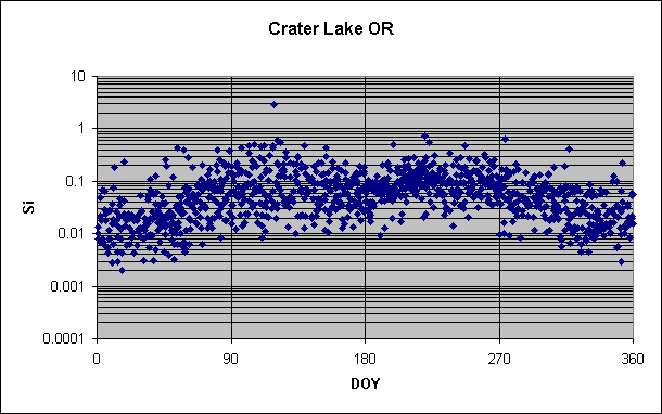
The low winter concentrations and the big spring peak are important because they
match the pattern in Hawaii, exemplified here by Haleakala. Since the winter and
spring concentrations in Oregon (and much of California and farther inland)
match those in Hawaii, the simplest interpretation is that they represent Si
transported from the Pacific. This conclusion is an extremely important and
provocative one, and must be tested further before it can be accepted. That is
done in the next two sections, the slide shows for Si vs Si at Haleakala and for
Ca/Si.
It must also be remembered that Si in fine aerosol over much
of the United States displays the pattern of low concentrations in winter
followed by rapidly rising values in spring, even at sites whose aerosol can
only be affected tangentially by material from over the Pacific. Thus we must be
very cautious not to overinterpret this western pattern.
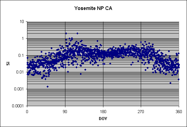
Down through California the basic pattern remains—low
in winter, big peak in spring, falloff to moderate summer values, a smaller fall
peak at some of the sites, and then a quick drop back to the low winter values.
A typical representative site, Yosemite National Park, is shown below.
The next slide show deals with the high summer and fall values; here we
concentrate on making the basic case that winter and spring look like the
Pacific throughout the near-coastal states of the West.
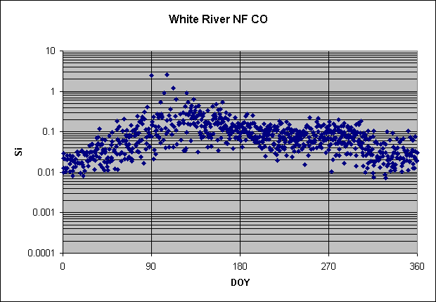
Now consider the next tier or two of states—Idaho,
western Montana, Nevada, Utah, and Arizona. Although the concentrations of Si
increase slightly from north to south, the basic pattern remains more similar
than different. Some places display more prominent summer concentrations than
others, and some have better-developed fall peaks, but the basic pattern
remains. Much the same holds for Wyoming, Colorado, and New Mexico. Quite a few
of the patterns from the West are carbon copies of each other. (At least at
first glance—the next section examines
them more closely.) Here is a typical example, from White River National Forest,
Colorado.
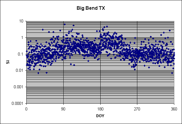
The pattern for Si changes abruptly as we enter the southeastern states. The first clue that something is happening is shown by Guadeloupe, in the northern panhandle of West Texas. There Si jumps up by a factor of three right at the beginning of July, and does not return to "normal" until September. The same thing is seen at Big Bend, Texas, in the southern part of the panhandle, but with a factor of increase of more like four to five. It begins abruptly at the same time—the first of July—and last for the same two months. Here is the plot for Big Bend.
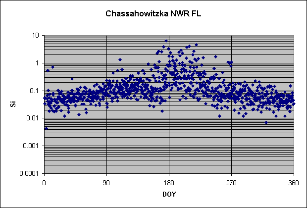
At first I was puzzled by these two sites. Eventually I noticed that their increases in Si corresponded to larger and better-known increases in Georgia (Okefenokee), Florida (Chassahowitzka and Everglades), and the Virgin Islands that are Saharan dust transported westward to North America by the summer trade winds of the tropical North Atlantic. Here is the plot for Chassahowitzka. Note the almost perfect match in the timing of the summer peak at the two places.
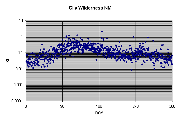
Although this dust is well known in places like Miami, Barbados, and Bermuda (and we have found it occasionally in Rhode Island), I had not appreciated that it reached West Texas and thereby Mexico. If you look hard, you can see indications of it in the southern parts of New Mexico and Arizona, but it is much weaker there than in Texas. (See the plot for Gila Wilderness, New Mexico, below.)
It also appears in Arkansas, southern Missouri, Tennessee, and Kentucky
(Upper Buffalo, Mingo, Great Smoky Mountains, Mammoth Cave), but on fewer
occasions and with lower concentrations. On the whole, however, it is fair to
say that Saharan dust is a regular feature of the entire Southeast.
How do we know that it is Saharan dust? This case is simpler
than the Asian case, for upwind of the Caribbean lies essentially only the
Sahara as a major source of dust, unless of course you want to try to invoke the
deserts of the Middle East, which is quite a stretch. Furthermore, this dust
brings with it a distinctive signal of low Ca/Si (as shown below), and is
embedded in a clean Atlantic air mass that also brings high marine aerosol and
very low pollution (low Pb here). So there is not much doubt about what is going
on.
Moving up the East Coast through the mid-Atlantic states, we
continue to see Saharan aerosol in summer through South Carolina (Cape Romain),
North Carolina (Swanquarter), and even into New Jersey (Brigantine). It peters
out beyond that, however. At the same time, the spring peak fades away and is
replaced by moderately high and steady concentrations throughout spring and
summer. Fall is a transition season back to the lower concentrations of winter,
which are two or three times below spring and summer. In other words, Si in the
Northeast is pretty bland.
The only area remaining to be discussed is the north central
states. The easternmost three boundary sites in Michigan and Minnesota appear to
have nearly flat patterns, but they don't have enough data points to define the
patterns with confidence. The western boundary site in Minnesota (Voyageurs)
shows more of a spring peak, a feature that increases in prominence as you move
farther west through the Dakotas and into Montana.
We can then summarize the patterns for Si as winter low,
spring peak, and summer moderate throughout most of the West, increasing summer
peak from Saharan dust eastward through the Southeast, and decreasing spring
peak northward into the mid-Atlantic states, the north central states, and New
England.
Ahead to Si vs. Si at Haleakala
Back to S vs. S at Mauna Loa